Monday, 30 June 2014

Day 51: Wilmington to Catninga Shed

Daily distance: 29.4km
Total distance: 895.5km

We woke early this morning to no rain so we packed and were out the hotel by 7am. The sun was just coming up in the east but west did not look too healthy with the mountains under cloud, obviously this was the direction we would be heading. We bid a sleepy Wilmington farewell, as we headed west on the Main North Road, (hey I didn't name it OK) up into the Flinders Rangers. It was misty but there was alot of light around as we rejoined the trail 3km from town. Four kilometers later we got to the monument for Horrocks Pass which we were in. Here the trail left the main drag at 90° and started heading due north straight up Cudmore Hill.

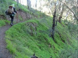
We took a quick break here for a bite to eat, both of us still very apprehensive about the weather especially as tonight we would have to camp somewhere. However the mist broke up in places and the sun shone through which made for some pretty dramatic scenery. One thing the Heysen people did get right on this stretch of the trail was the hills..... they did not miss one of the batards! We spent the whole day going up and down, up and down, but the great thing is the weather cleared and by mid afternoon we were in bright sunshine. The sad thing was that after 20km from leaving Wilmington we could still see it very clearly not too far away. Heart breaking stuff....

The area we walked through was wild country with very little in the way of any habitation here. We saw a lot of Euro's, also known as Wallarroos, Grey Kangaroo and what we think is a Wallabie of sorts. Smaller, lighter in colour with rounded ears and short front legs. Will have to look that one up when I get to see a mammal book again. Even the sheep messed there wool when they saw us!

The trail followed fence lines most of the day with the odd creek bed thrown in. The planners did not take into account the creeks would all be flowing strongly this time of the year so we had to do some pebble hopping along the way. There has been so much rain here that every little gully is flowing. At the moment we are 300m above the closest flowing water and we can still hear it. Seeing the area like this is very special as I am sure not many people get to see it in full flow.

When we were 3km away from the Catninga Shed the trail started following a creek bed again and took us up the most amazing valley between two 1000m peaks. Following a creek bed is not always as straight as one might hope so the 3km became a lot longer with a few more very steep slopes thrown in. It was late in the day when we finally saw the shed ahead of us and it took some quick reorganizing the verandah (shed is locked) for us to get our tent up under cover. Some corrigated iron sheets went up round the sides of us so we are pretty well protected from the wind. However if it does pick up the iron will be "gone with the wind".........

Tomorrow the last couple of hundred meters to the top of Mount Brown and with a bit of luck we will make Quorn, a fairly large town. Why I say with a bit of luck, is that I have a new pair of boots waiting for me there. These, second pair, gave up the hosts a couple of days ago and are just being held together by really dirty, smelly, sticky socks. So a new pair will be welcome........ not to mention getting some clothes washed.

Saturday, 28 June 2014

Day 50: Grays Hut to Wilmington

Daily distance: 22.4km
Total distance: 866.1km

A very, very cold night with hectic winds and lots of rain. The wind was so strong at stages last night the door blew open, so we moved the fire extinguisher in front of it to try stop it, which did the trick. If anybody had come into the hut last night all they would have seen of the two of us would have been our noses. We had our sleeping bags up to our eye ball's with hoods drawn tight.

This morning was heavielly overcast but the rain had abated for awhile, so we packed up as quick as possible, put everything waterproof we had on, and shot out the door. A kilometer later we got stopped in our tracks, by a stream the trail took us over, that was in full spat. Shoes off and through we went, no way round. To tell you it was cold would be funny, it was so cold my little toes went inverted!

Well, this was the name of the game for the rest of the day. Every stream we came to was over flowing so we had to either, jump, wade, skip, swim or use Dee as a spring board, to get across. It was also a very tough day with a huge amount of ups and downs. Everytime we got to the top of one crest, we would see another higher one just across the valley and thats exactly where the trail took us.... over all of them. The rain feel continuously the whole day so it was not long before we were soaked, so stopping was not an option. As we got to the last peak before descending to the flat lands, down came the sleet.... yip sleet. I haven't seen sleet since I was on Marion Island and then I had long pants on........

Twenty minutes later the sleet was still coming down but we were half way down the mountain. Stumbling along looking for the trail, through all the hoodies I had on, I heard a babbler calling. To Dee's total amazement I started spishing and out came 4 or 5 White-browed Babblers. Lifer!!!!

Reaching the bottom we came into the Stony Creek Campsite, which was partially under water, had a look and carried on towards Wilmington. Two hours later we reached the Main North Road and the Wilmington Caravan Park where we now are watching the TV and drinking warm coffee.

I apologise for the lack of photos from today but it was just to wet and cold to keep taking gloves off to get pictures. Anyway too many pictures of rain would make you all depressed. You will also notice on the photo of the stats that the walking time was something horrendous. Well I forgot to switch it off when we got here so it's a bit longer than the actual walk was. However the ascent and descent should tell you our story ...... Until the sun shines.......

Day 49: Melrose to Grays Hut

Daily total: 12.4km
Total distance: 843.7km

Had a lie in this morning as we did not have a long way to go and evemtually left the caravan park at 9am. The trail goes through the caravan park so we were on it right away and crossed a hanging bridge over a stream before heading up to the War Memorial for the men who had fallen in the First World War. Great veiws of Melrose from this evevated position which is the start of a lot of different trails, both walking and mountain biking.

From this point on the walk went from great, to frigging awesome. The trail wound it's way around the north eastern side of Mount Remarkable along the edge of the face. As the photos show you some of these slope are pretty sheer in places and takes a sure foot to get across. However, for all the discomfort in the climb and the steep slopes, the trail made up for it with stunning views. We could see for at least 40km over agriculture land to other mountains off to the east. After one particular large and steep scree slope Dee pointed out an aeroplane wreck in the valley below and told me the story of a small plane flying into the side of the mountain in some thick mist. When you see the mountain you understand why John Eyre named it Mount Remarkable in 1840. It simply juts out of the plain and is there.

We had our muesli on the slopes looking over the plains before rounding the face and getting onto the exposed side of the mountain. Here the wind was very gusty and cold. Not that cold was a problem climbing this steep mountain. Six kilometers later we crested the summit in very strong winds to find an old gentleman sitting at the top in his shorts and t-shirt with a small day pack. He was built like a piece of lean biltong and Dee made the comment that he probably does this walk everyday. We tried to chat but the wind was too loud so he said cheers and wandered off down the slope the way we had come. There is a pile of rocks at the summit, so like travellers coming past, each put a stone on, so Dee and I put ours on before heading down the opposite side of the mountain.

Going down was alot straighter than up so alot quicker but also very tiring on the knees. A few stops later and the trail took us off the road into the most amazing green valley with a crystal clear stream flowing at the bottom. We were so enthralled in the valley we missed a critical marker and only realized it about a kilometer later. No worries we decided to head straight over the mountain rather than back track as the track was only 450m away....... mmmmm.... Then started the fun and games... Up and up and up and up we went at times on all fours and the bloody hill, or what looked like a small hill from the bottom, turned into a long drawn out cliff face. Eish, by the time we got to the top my calves were on fire and my quads were shaking they were so tired. Dee did not answer anything I said and just plain ignored me. I guess she was tired as well!

Once we crested 'everest' and found our trail it was not far till we came out at the hut. Named Grays Hut after the family who lived here with milk cows and taking the milk to Melrose once a week by wagon, a distance of 16km. The hut only burnt down in 1988 and was restored for hikers. Fantastic!

We made it just in time cause not long after we got here it started raining and is still doing so now. Tomorrow we were hoping to get to the next town or Wilmington, but we will have to wait and see what the weather does cause if it's like it is now..... well they can rename this place to "Deehut".

Thursday, 26 June 2014

Day 47: Wirrabara to Murray Town

Daily distance: 15.7km
Total distance: 812km

Started off a bit later than usual this morning as we only had a short distance to go..... well to be totally honest we actually just wanted to see what the weather was going to do. As it turned out it was overcast but no wind and most importantly no rain.

We headed north out of Wirrabara along the Main North Road for about 4km before we stopped for a break. Walking along a busy main road is not fun and actually very demoralising.  Four kilometers later we stopped for a bite to eat at the Warrayong Hall and pistol club. I cant tell you much about Warrayong as that is the extent of it.... a hall..... The trail from there followed farm roads over the hills which lifted the spirits as well as my head.

A few zigs and some zags through the farmlands brought us out about 2km from Murray Town at which stage we turned off the track to head down to the town. Mount Remarkable is looming on the horizon off in the north waiting for us to get to it in a couple of days. As usual the Heysen Trail will, and does, go straight over the top of it..... can't wait!

Murray Town is as big as the first letter of the main... yip one block and we are in the coffee shop (only shop) having a coffee and  carrot cake. Perfect little coffee shop  (waiting for its liquor licence to become a bar) with a log fire, excellent cake and friendly service. All it needs now is beer and a room and I'd be in heaven!

We have found our camping spot across the road in the footy club stands. Big enough for us to put our tent up under the roof, has a toilet, plug points and is dry. Can't wait for bed.